
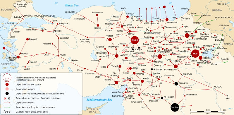
Image: Armenian Genocide Map-en

Description: Map of the Armenian Genocide in 1915. Each size shows a massacre. There are three types of massacre: in a control centre (red dot), in a station (pink dot), in a concentration and annihilation center (black dot). The size of the dot shows the relative number of killed Armenians. Each pair of swords shows an area of Armenian resistance: greater resistance (red swords) or lesser resistance (black swords). The different size of swords is to save space into the map, it means nothing. Dots in Black Sea representing Armenians (mainly women and children) drowned into the sea (see Armenian Genocide for references).
Title: Armenian Genocide Map-en
Credit: Topographic background : NASA Shuttle Radar Topography Mission (SWBD) (public domain) Armeniangenocidemap.gif by Vahagn Avedian, from the website http://www.armenica.org, uploaded on Commons by Electionworld under license GFDL. (Note: Armenica map is a clone of Map 224 (The Armenian Genocide, 1915 (after J. Naslian and B.H. Harutyunyan) in Hewsen, Robert H. (2001) Armenia: A Historical Atlas (1st ed.), University of Chicago Press, pp. 232 ISBN 0-226-33228-4Other data : Cartographic projection : UTM Geodetic system : WGS84
Author: Sémhur
Usage Terms: Creative Commons Attribution-Share Alike 3.0
License: CC BY-SA 3.0
License Link: https://creativecommons.org/licenses/by-sa/3.0
Attribution Required?: Yes
Image usage
The following 2 pages link to this image:
