
Image: ArrTurnhoutLocatie
No higher resolution available.
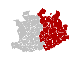
ArrTurnhoutLocatie.png (270 × 203 pixels, file size: 5 KB, MIME type: image/png)
Description: This map indicates (in red) the location of administrative and judicial arrondissements of Turnhout in the province of Antwerp, Belgium. Both maps are the same and fill all the province of Antwerp. In this case, a redirection is avalaible at File:Judicial_Arrondissement_Turnhout_Belgium_Map.png for an easy and intuitive access to judicial arrondissement map.
Title: ArrTurnhoutLocatie
Credit: Own work
Author: w:nl:Gebruiker:Westermarck
Usage Terms: Creative Commons Attribution-Share Alike 3.0
License: CC-BY-SA-3.0
License Link: http://creativecommons.org/licenses/by-sa/3.0/
Attribution Required?: Yes
Image usage
The following page links to this image:

All content from Kiddle encyclopedia articles (including the article images and facts) can be freely used under Attribution-ShareAlike license, unless stated otherwise.