
Image: Australia South Australia City of Playford location map

Size of this PNG preview of this SVG file: 800 × 317 pixels. Other resolution: 320 × 127 pixels.
Original image (SVG file, nominally 1,027 × 407 pixels, file size: 5.32 MB)
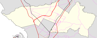
Description: Location map for en:City of Playford showing LGA boundaries, railways, major roads
Title: Australia South Australia City of Playford location map
Credit: data from Government of South Australia http://data.sa.gov.au
Author: ScottDavis at English Wikipedia
Permission: Source data was released by the Government as
Usage Terms: Creative Commons Attribution 3.0
License: CC BY 3.0
License Link: https://creativecommons.org/licenses/by/3.0
Attribution Required?: Yes
Image usage
The following 22 pages link to this image:
- Andrews Farm
- Bibaringa
- Craigmore, South Australia
- Edinburgh North, South Australia
- Elizabeth Downs
- Elizabeth East
- Elizabeth Grove
- Elizabeth North
- Elizabeth South
- Elizabeth West, South Australia
- Hillbank, South Australia
- Munno Para, South Australia
- Munno Para Downs, South Australia
- Munno Para West, South Australia
- Penfield, South Australia
- Penfield Gardens, South Australia
- Sampson Flat
- Smithfield, South Australia
- Smithfield Plains, South Australia
- Uleybury
- Virginia, South Australia
- Yattalunga, South Australia

All content from Kiddle encyclopedia articles (including the article images and facts) can be freely used under Attribution-ShareAlike license, unless stated otherwise.