
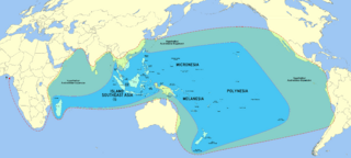
Image: Austronesia with hypothetical greatest expansion extent (Blench, 2009) 01

Size of this preview: 800 × 361 pixels. Other resolutions: 320 × 144 pixels | 8,696 × 3,920 pixels.
Original image (8,696 × 3,920 pixels, file size: 4.96 MB, MIME type: image/png)
Description: Austronesia with hypothetical greatest expansion extent per Blench, Roger (2009). "Remapping the Austronesian expansion". In Evans, Bethwyn. Discovering History Through Language: Papers in Honour of Malcolm Ross. Pacific Linguistics. ISBN 9780858836051.
Title: Austronesia with hypothetical greatest expansion extent (Blench, 2009) 01
Credit: File:Blank map of the world (Robinson projection) (162E).svg
Author: BlankMap-World-162E.svg: Lokal_Profil derivative work: Milenioscuro (talk) derivative work: Obsidian Soul]
Usage Terms: Creative Commons Zero, Public Domain Dedication
License: CC0
License Link: http://creativecommons.org/publicdomain/zero/1.0/deed.en
Attribution Required?: No
Image usage
The following page links to this image:

All content from Kiddle encyclopedia articles (including the article images and facts) can be freely used under Attribution-ShareAlike license, unless stated otherwise.
_01.png)