
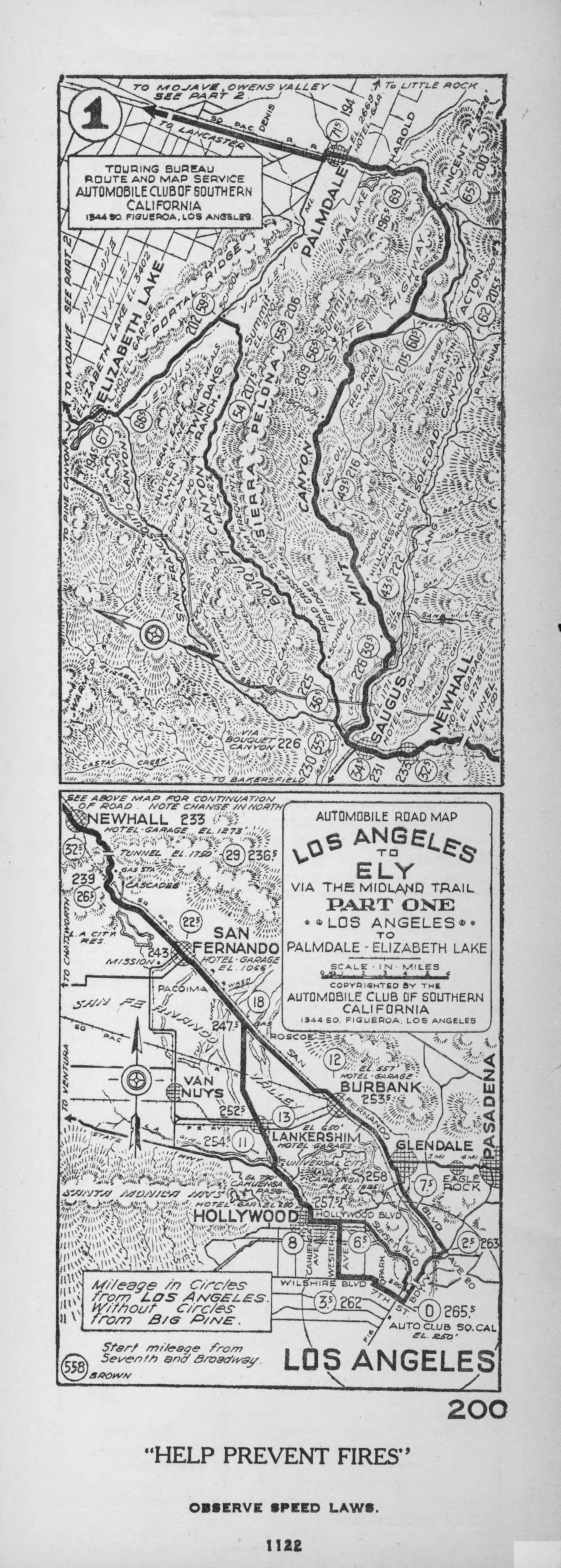
Image: Automobile road map- Los Angeles to Ely via the Midland Trail. Part one- Los Angeles to Palmdale-Elizabeth Lake, 1922 (AAA-SM-005598)
Description: Automobile road map: Los Angeles to Ely via the Midland Trail. Part one: Los Angeles to Palmdale-Elizabeth Lake, 1922 Strip map of automobile routes from Los Angeles to Palmdale and Elizabeth Lake. In two sections. Top section bounded by: Southern Pacific Railroad (top), Castaic Creek (bottom), Elizabeth Lake (left), Acton (right). Through theand Sierra Pelona Mountains. Bottom section bounded by: Newhall (top & left), Los Angeles (bottom), Pasadena (right). Due north is about 75 degrees left of vertical (top section) and straight up (bottom section). Principal features: municipalities, roads, railroads, road names, mileages, elevations, services. Other prominent locations (top section): Antelope Valley, Sierra Pelona, Saugus, Mint Canyon, Bouquet Canyon, San Francisquito Canyon. Other prominent locations (bottom section):, San Fernando Road (Route 99), Sylmar, Verdugo Mountains, San Fernando, Van Nuys, Burbank, Lankershim, Glendale, Cahuenga Pass, Santa Monica Mountains, Hollywood. Printed at bottom is "558", "Brown" and, at top, part "1". Printed at bottom, outside of map itself, is "200", "1122, "'Help prevent fires'" and "Observe speed laws". On verso is notice to look for official hotels and garages with a list of 7 hotels and 59 garages (with addresses). Legacy record ID: acsc-m94 Filename: AAA-SM-005598; AAA-SM-005598v Coverage date: 1922-11-01 Part of collection: Automobile Club of Southern California collection, 1892-1963 Type: maps; texts Geographic subject (city or populated place): Los Angeles; Palmdale; Pasadena; Newhall; Santa Clarita; Elizabeth Lake; Acton Publisher (of the Digital Version): University of Southern California. Libraries Cartographer: Brown Part of subcollection: Automobile Club of Southern California strip maps, 1912-1936 Repository address: 2601 South Figueroa Street, H-118, Los Angeles, CA 90007-3294, USA Geographic subject (country): USA Format (aacr2): map : b&w ; 27 x 10 cm. Language: English Rights: Automobile Club of Southern California Repository name: Automobile Club of Southern California Subject (adlf): roadways Repository email: yates.morgan@aaa-calif.com Contributing entity: Automobile Club of Southern California Date created: 1922-11-01 Call number: SMC Box 41 (5598) Geographic subject (manmade feature): Southern Pacific Railroad Format (aat): strip maps; cartographic material Creator: Automobile Club of Southern California. Touring Bureau. Route and Map Service (1344 South Figueroa Street, Los Angeles) Geographic subject (state): California Geographic subject: creeks: Castaic Creek; lakes: Elizabeth Lake Access conditions: 213-741-4486; http://www.aaa-calif.com Geographic subject (county): Los Angeles Subject (lcsh): Maps, Tourist
Title: Automobile road map- Los Angeles to Ely via the Midland Trail. Part one- Los Angeles to Palmdale-Elizabeth Lake, 1922 (AAA-SM-005598)
Credit: http://digitallibrary.usc.edu/cdm/ref/collection/p15799coll59/id/143
Author: Unknown authorUnknown author
Usage Terms: Public domain
License: Public domain
Attribution Required?: No
Image usage
The following page links to this image:

.jpg)