
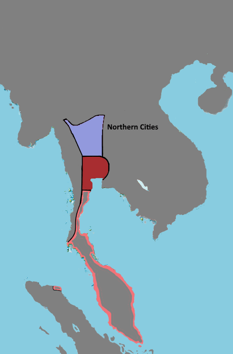
Image: Ayutthaya Kingdom map in the 14th century
Description: Dark red represents the heartland of the original Ayutthaya polity (Suphanburi, Lopburi, and Ayutthaya), which may also have been the boundaries of Dvaravati culture. Fully colored light red represents territories invaded by Ayutthaya. Blue is the Northern Cities, which was independent at this time but contributed significantly to Ayutthaya's economy, government, military, and culture.
Title: Ayutthaya Kingdom map in the 14th century
Credit: Own work Baker, Chris. Ayutthaya Rising: From Land or Sea?. Journal of Southeast Asian Studies. Baker, Chris. Phongpaichit, Pasuk. A History of Ayutthaya Siam in the Early Modern World. Kasetsiri, Charnvit. The Rise of Ayudhya: A History of Siam in the Fourteenth and Fifteenth Centuries. Watson, Hunter Ian. Old Mon inscriptions and the Dvāravatī culture. Youtube. SOAS University of London. https://www.youtube.com/watch?v=SyApgkop11k
Author: Yourlocallordandsavior
Usage Terms: Creative Commons Attribution-Share Alike 4.0
License: CC BY-SA 4.0
License Link: https://creativecommons.org/licenses/by-sa/4.0
Attribution Required?: Yes
Image usage
The following page links to this image:
