
Image: Bandelier satphoto Winter 2015

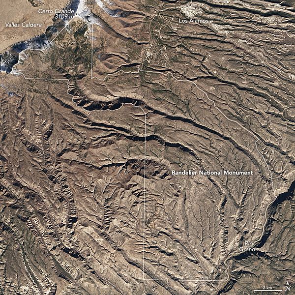
Description: On December 5, 2015, the Operational Land Imager (OLI) on Landsat 8 captured a natural-color image of Bandelier (top). The monument area encompasses about 130 square kilometers (50 square miles) of land west of Santa Fe and adjacent to Los Alamos National Laboratory. The second image was acquired by National Park Service photographer Sally King. It shows the tall walls of Frijoles Canyon and some dwellings along its base—a site called Long House. These remnants of earlier human presence are too small to be spotted from space, but you can get a sense of the landscape that made it a favorable place to build. The cliffs are soft volcanic tuff, composed of consolidated ash from the eruption of the Jemez Volcano more than 1 million years ago. The volcano’s summit collapsed and formed the Valles Caldera, visible in the top left corner of the Landsat image. Rising from the rim of the caldera, and marking Bandelier’s northwestern boundary, is the snow-capped summit of Cerro Grande—the monument’s highest elevation at 3109 meters (10,199 feet). From that mountaintop down to Bandelier’s southeastern boundary on the banks of the Rio Grande, the land loses almost a vertical mile of elevation. Most of the landscape is designated as wilderness area, and it is lined with deep canyons sharply eroded from the plateaus. The landscape appears more stark and brown in the satellite image than it might at other times of the year. “The winter scene really lets you see the landscape without much vegetation softening it,” said Kay Beeley, an NPS cartographic technician for Bandelier National Monument. “This image catches Bandelier at one of the least active times of the year for vegetation growth,” said Craig Allen, a U.S. Geological Survey ecologist at Bandelier. “The vegetation is quite dormant at all elevations in December due to relatively cold winter temperatures.”
Title: Bandelier satphoto Winter 2015
Credit: http://earthobservatory.nasa.gov/IOTD/view.php?id=87460&src=eoa-iotd
Author: NASA Earth Observatory image by Jesse Allen, using Landsat data
Permission: This file is in the public domain in the United States because it was solely created by NASA. NASA copyright policy states that "NASA material is not protected by copyright unless noted". (See Template:PD-USGov, NASA copyright policy page or JPL Image Use Policy.) Warnings: Use of NASA logos, insignia and emblems is restricted per U.S. law 14 CFR 1221. The NASA website hosts a large number of images from the Soviet/Russian space agency, and other non-American space agencies. These are not necessarily in the public domain. Materials based on Hubble Space Telescope data may be copyrighted if they are not explicitly produced by the STScI.[1] See also Template:PD-Hubble and Template:Cc-Hubble. The SOHO (ESA & NASA) joint project implies that all materials created by its probe are copyrighted and require permission for commercial non-educational use. [2] Images featured on the Astronomy Picture of the Day (APOD) web site may be copyrighted. [3] The National Space Science Data Center (NSSDC) site has been known to host copyrighted content even though its photo gallery FAQ states that all of the images in the photo gallery are in the public domain.
Usage Terms: Public domain
License: Public domain
Attribution Required?: No
Image usage
The following page links to this image:
