
Image: Barkly Tableland Map

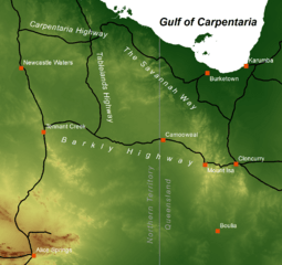
Description: This is a map of the Barkly Tableland, which extends from the eastern Northern Territory (near Daly and Newcastle Waters) into Western Queensland (almost to Mt Isa). The map features major highways and selected towns. The background is an elevation model, giving a rough idea of the tableland's area, which is the somewhat uniformly coloured area around the appropriately named Barkly and Tableland Highways. The green in that area corresponds to an elevation of about 200 to 300 metres. Elevation data is from the SRTM30 dataset published by the USGS, thus being in the public domain. The data has been retrieved via http://diva-gis.org/gdata. Roads and populated places have been taken from Natural Earth's 10m cultural vectors set at http://www.naturalearthdata.com/downloads/10m-cultural-vectors/, which is public domain as well. The map was created using ESRI ArcMap 10.2.2.
Title: Barkly Tableland Map
Credit: Own work
Author: Christallkeks
Usage Terms: Creative Commons Attribution-Share Alike 4.0
License: CC BY-SA 4.0
License Link: https://creativecommons.org/licenses/by-sa/4.0
Attribution Required?: Yes
Image usage
The following page links to this image:
