
Image: Basin of Mexico 1519 map-en

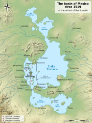
Description: Map of the basin of Mexico circa 1519, at the arrival of the Spanish.
Title: Basin of Mexico 1519 map-en
Credit: File:Lago de Texcoco-posclásico.png, itself from : (fr) Niederberger Betton, Christine (1987) Paléo-paysages et archéologie pré-urbaine du Bassin de Mexico, Mexico: Centro de estudios mexicanos y centroamericanos (CEMCA), pp. 500 ISBN: 3785726. File:Valley of Mexico c.1519-fr.svg, itself from : (en) Coe, Michael; Snow, Dean; Benson, Elizabeth (1986) Atlas of Ancient America, Category:New York: Facts On File, pp. 240 ISBN: 978-0816011995. (en) Townsend, Richard F. (1992) The Aztecs, London: Thames & Hudson, pp. 224 ISBN: 978-0500021132. (es) This picture incorporates information from La cuenca de México, special edition of Arqueología Mexicana, july-august 2007, Mexico (in particular, the Enrique Vela's maps of the pages 70 and 60, based on Sanders et al. The Basin of Mexico, 1979). (es) This picture incorporates information from this version of the article Lago de Texcoco on the Spanish Wikipedia.
Author: File:Lago de Texcoco-posclásico.png: Yavidaxiu File:Valley of Mexico c.1519-fr.svg: historicair 13:51, 11 September 2007 (UTC) derivative work: Sémhur
Usage Terms: Creative Commons Attribution-Share Alike 4.0
License: CC BY-SA 4.0
License Link: https://creativecommons.org/licenses/by-sa/4.0
Attribution Required?: Yes
Image usage
The following 6 pages link to this image:
