
Image: Basse Mésopotamie Uruk
No higher resolution available.
Basse_Mésopotamie_Uruk.png (440 × 393 pixels, file size: 150 KB, MIME type: image/png)
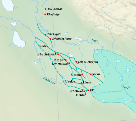
Description: Sites de la Basse Mésopotamie durant le IVe millénaire av. J.-C. (période d'Uruk). Tracé des cours d'eau d'après Guillermo Algaze, Ancient Mesopotamia at the Dawn of Civilization: The Evolution of an Urban Landscape, Chicago, University of Chicago Press, 2008, fig. 5 p. 45.
Author: Near_East_topographic_map-blank.svg: Sémhur derivative work: Zunkir (talk)
Usage Terms: Creative Commons Attribution-Share Alike 3.0
License: CC-BY-SA-3.0
License Link: http://creativecommons.org/licenses/by-sa/3.0/
Attribution Required?: Yes
Image usage
The following page links to this image:

All content from Kiddle encyclopedia articles (including the article images and facts) can be freely used under Attribution-ShareAlike license, unless stated otherwise.