
Image: Belfast Aerial

Size of this preview: 450 × 600 pixels. Other resolutions: 180 × 240 pixels | 1,944 × 2,592 pixels.
Original image (1,944 × 2,592 pixels, file size: 1.68 MB, MIME type: image/jpeg)
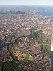
Description: Aerial photo of south-east, central and north Belfast, taken from a plane on a clear evening, 9th September 2004. Includes the River Lagan, Stranmillis, Annadale Embankment, Ormeau Road, Ravenhill Road, Ormeau Park, City Hospital, parts of east and west Belfast, Belfast Docks, Mallusk, Cave Hill, Carnmoney Hill and extends to the Glens of Antrim, Causeway Coast and the coast of Scotland in the distance.
Title: Belfast Aerial
Credit: Own work
Author: Fattonyni
Usage Terms: Creative Commons Attribution-Share Alike 4.0
License: CC BY-SA 4.0
License Link: http://creativecommons.org/licenses/by-sa/4.0
Attribution Required?: Yes
Image usage
The following page links to this image:

All content from Kiddle encyclopedia articles (including the article images and facts) can be freely used under Attribution-ShareAlike license, unless stated otherwise.