
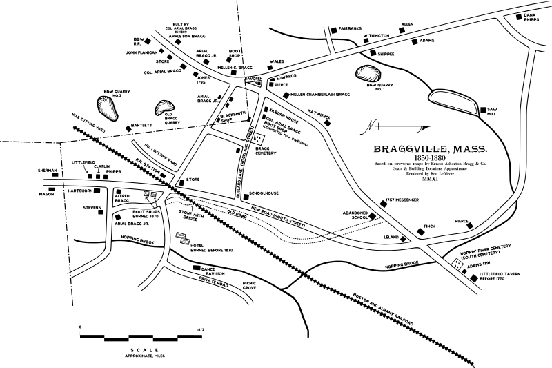
Image: Braggville 1850-1880, Map of

Description: Map of Braggville, Massachusetts, showing landmarks extant from 1850 through 1880. The thick dashed lines towards the left side of the map define the town and county boundary lines, with Holliston, Massachusetts of Middlesex County to the east, Medway, Massachusetts of Norfolk County to the southwest, and Milford, Massachusetts of Worcester County to the northeast. This map isn't accurate down to exact detail but is an approximate representation of the community of Braggville based on the locations of Washington Street and Adams Street today. Braggville has no defined borders, this map only represents what Ernest Atherton Bragg considered to be the post-village of Braggville.
Title: Braggville 1850-1880, Map of
Credit: Own work, re-rendered to scale, based on rough maps by Ernest A. Bragg, and another by an unknown author shown in Holliston: A Good Town by Joanne Hulbert
Author: Simtropolitan
Permission: This file is licensed under the Creative Commons Attribution 3.0 United States license. You are free: to share – to copy, distribute and transmit the work to remix – to adapt the work Under the following conditions: attribution – You must attribute the work in the manner specified by the author or licensor (but not in any way that suggests that they endorse you or your use of the work). http://creativecommons.org/licenses/by/3.0/us/deed.en CC BY 3.0 us Creative Commons Attribution 3.0 us truetrue
Usage Terms: Creative Commons Attribution 3.0 us
License: CC BY 3.0 us
License Link: http://creativecommons.org/licenses/by/3.0/us/deed.en
Attribution Required?: Yes
Image usage
The following page links to this image:
