
Image: Brainerd Mission map
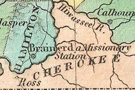
Description: A beautiful example of Finley's important 1827 map of Tennessee. Depicts the state with moderate detail in Finley's classic minimalist style. Shows river ways, roads, canals, and some topographical features. Offers color coding at the county level. Title and scale in upper left quadrant. Finley's map of Tennessee is particularly interesting and important due to its portrayal of the rapidly changing American Indian situation in the south eastern part of the state. In 1827 a substantial part of southeastern Tennessee and northwestern Georgia was a confined territory assigned to the Lower Creek and Cherokee nations. Finley's map details the borders of this country as defined by the Tennessee and Hiwasssee Rivers. Also notes American Indian villages and missionary stations, including the Brainerd Mission, within and adjacent to the Cherokee territory. Just four years after this map was made the Creek and Cherokee would forcibly relocated westward in the infamous Trail of Tears. Engraved by Young and Delleker for the 1827 edition of Anthony Finley's General Atlas .
Title: Brainerd Mission map
Credit: 1827_Finley_Map_of_Tennessee_-_Geographicus_-_Tennessee-finley-1827.jpg
Author: 1827_Finley_Map_of_Tennessee_-_Geographicus_-_Tennessee-finley-1827.jpg: Anthony Finley derivative work: StAnselm (talk)
Usage Terms: Public domain
License: Public domain
Attribution Required?: No
Image usage
The following 3 pages link to this image:
