
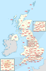
Image: British postcode areas map

Description: Labelled map of Royal Mail postcode areas of the United Kingdom and Crown Dependencies with insets for Manchester and London conurbations. Equirectangular projection with latitude stretching 170%, WGS84 datum. Geographic limits: Main 1:5,000,000 map: West: 11.00W East: 2.20E North: 61.00N South: 49.00N Manchester 1:3,000,000 inset map: West: 3.30W East: 1.10W North: 54.10N South: 53.10N London 1:1,000,000 inset map: West: 0.50W East: 0.30E North: 51.70N South: 51.30N
Title: British postcode areas map
Credit: Derived from Ordnance Survey OS OpenData. Postcode area boundaries within Great Britain derived from Voronoi polygons of OS Code-Point Open unit postcode median coordinates (with coastline clipping and minor adjustments to avoid spurious detached polygons). National borders and coastline data derived: from OS Strategi for inset maps from File:United Kingdom location map.svg (version 2011-01-11T22:14:29) for main map coastline and Ireland border.
Author: Richardguk
Usage Terms: Creative Commons Attribution-Share Alike 3.0
License: CC BY-SA 3.0
License Link: https://creativecommons.org/licenses/by-sa/3.0
Attribution Required?: Yes
Image usage
The following 2 pages link to this image:
