
Image: Canadian pop from 1851 to 1921

Size of this preview: 421 × 599 pixels. Other resolutions: 169 × 240 pixels | 2,130 × 3,030 pixels.
Original image (2,130 × 3,030 pixels, file size: 1.95 MB, MIME type: image/jpeg)
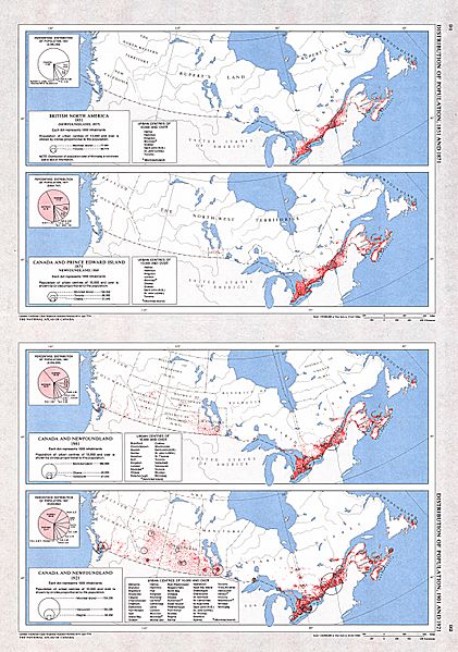
Description: A collection of four maps showing the distribution of population for 1851 (Newfoundland 1857), 1871 (Newfoundland 1869), 1901 and 1921 by historical region. A supplementary chart for each map shows the percentage of population by province and territory. As well, for each map, a text listing urban centres with historical populations of 10 000 or more is provided.
Title: Canadian pop from 1851 to 1921
Credit: The Atlas of Canada
Author: Natural Resources Canada
Permission: Copyright / Permission to Reproduce (GeoGratis)
Usage Terms: Creative Commons Attribution 2.5
License: CC BY 2.5
License Link: http://creativecommons.org/licenses/by/2.5
Attribution Required?: Yes
Image usage
The following page links to this image:

All content from Kiddle encyclopedia articles (including the article images and facts) can be freely used under Attribution-ShareAlike license, unless stated otherwise.