
Image: Carlisle aerial westward

Size of this preview: 800 × 600 pixels. Other resolutions: 320 × 240 pixels | 2,272 × 1,704 pixels.
Original image (2,272 × 1,704 pixels, file size: 1.78 MB, MIME type: image/jpeg)
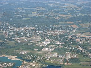
Description: Aerial view of Carlisle, a city split between Montgomery and Warren counties in the southeastern part of the U.S. state of Ohio. Picture taken from a Diamond Eclipse light airplane at an altitude of 4,540 feet MSL and a bearing of approximately 270º.
Title: Carlisle aerial westward
Credit: Own work
Author: Nyttend
Permission: I, the copyright holder of this work, release this work into the public domain. This applies worldwide. In some countries this may not be legally possible; if so: I grant anyone the right to use this work for any purpose, without any conditions, unless such conditions are required by law.
Usage Terms: Public domain
License: Public domain
Attribution Required?: No
Image usage
The following page links to this image:

All content from Kiddle encyclopedia articles (including the article images and facts) can be freely used under Attribution-ShareAlike license, unless stated otherwise.