
Image: Carte de l'Empire Français 1812

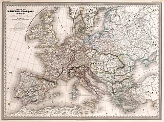
Description: Carte de l'Empire Francais 1812 : Dresse par A.H. Dufour. Gravee par Ch. Dyonnet. Paris, Armand Le Chevalier, Rue Richelieu, 60. La Lettre gravee par Deletre. Impe. par Louis Antonie, r. de Cluny 1, Paris. (to accompany) Atlas Universel, Physique, Historique Et Politique De Geographie Ancienne Et Moderne. Pl. 9. (on upper margin) Geographie historique Pl. 4.
Title: Carte de l'Empire Français 1812
Credit: David Rumsey Map Collection.
Author: Dufour, Auguste-Henri (1798-1865).
Permission: Public domainPublic domainfalsefalse This work is in the public domain in its country of origin and other countries and areas where the copyright term is the author's life plus 100 years or fewer. You must also include a United States public domain tag to indicate why this work is in the public domain in the United States. This file has been identified as being free of known restrictions under copyright law, including all related and neighboring rights. https://creativecommons.org/publicdomain/mark/1.0/PDMCreative Commons Public Domain Mark 1.0falsefalse
Usage Terms: Public domain
License: Public domain
Attribution Required?: No
Image usage
The following page links to this image:
