
Image: Celtic expansion
No higher resolution available.
Celtic_expansion.PNG (450 × 314 pixels, file size: 11 KB, MIME type: image/png)
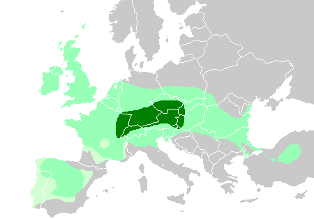
Description: Maximum Celtic expansion in Europe. Based on Celts in Europe.png. This map shows: Core Hallstatt territory, expansion before 500 BC Maximum Celtic expansion by the 3rd century BC Aquitanian area of Gaul, and Lusitanian area of Iberia, "Celticity" uncertain
Title: Celtic expansion
Credit: derivative of File:Celts in Europe.png
Author: User:QuartierLatin1968, User:Dbachmann, User:The Ogre
Usage Terms: Creative Commons Attribution-Share Alike 3.0
License: CC BY-SA 3.0
License Link: http://creativecommons.org/licenses/by-sa/3.0
Attribution Required?: Yes
Image usage
The following page links to this image:

All content from Kiddle encyclopedia articles (including the article images and facts) can be freely used under Attribution-ShareAlike license, unless stated otherwise.