
Image: China, North Korea, and South Korea map with craton and tectonic elements final 3

Size of this preview: 718 × 599 pixels. Other resolutions: 288 × 240 pixels | 1,373 × 1,146 pixels.
Original image (1,373 × 1,146 pixels, file size: 74 KB, MIME type: image/png)
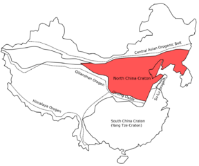
Description: Tectonic Map showing the position of the North China Craton in the Eastern Asia domain. Note that the names of the Cratons are only provided for North and South China Cratons. The Western blocks are called Himalayan Plateau Block (S) and Tarim Block (N)
Title: China, North Korea, and South Korea map with craton and tectonic elements final 3
Credit: Own work
Author: Celiayangyy
Usage Terms: Creative Commons Attribution-Share Alike 4.0
License: CC BY-SA 4.0
License Link: https://creativecommons.org/licenses/by-sa/4.0
Attribution Required?: Yes
Image usage
The following page links to this image:

All content from Kiddle encyclopedia articles (including the article images and facts) can be freely used under Attribution-ShareAlike license, unless stated otherwise.