
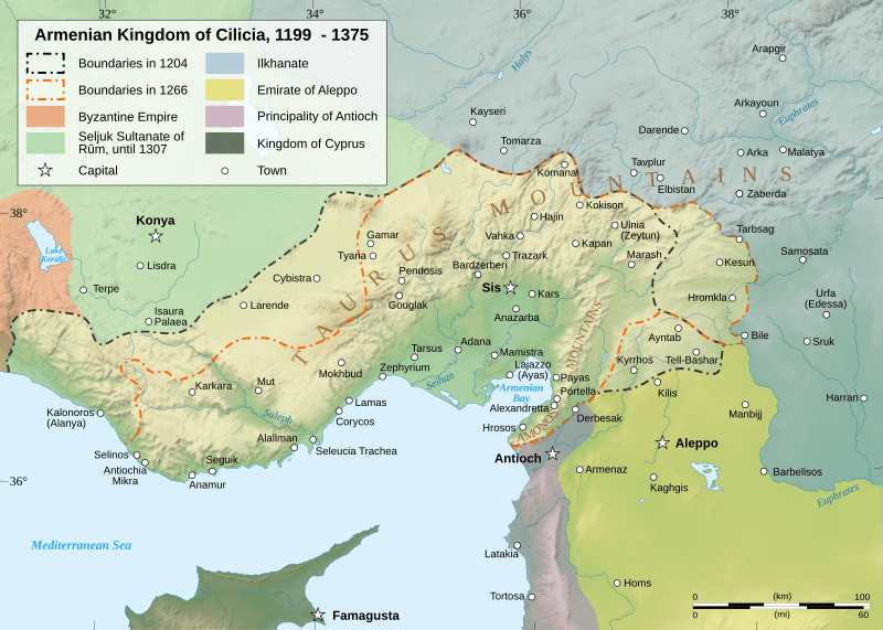
Image: Cilician Armenia-en

Description: English: Map of the Armenian Kingdom of Cilicia during the XIII century.
Title: Cilician Armenia-en
Credit: English: Sources : Topographic background : NASA Shuttle Radar Topography Mission (SRTM30 v.2) (public domain) Map of Cilician Armenia : Image:Armenianmeds.gif, uploaded on Commons by TigranMets, under license « GFDL ». Original map comes from http://armenica.org/. Permission has been received from the copyright holder to license this material under the GNU Free Documentation License. Rivers : Demis Scale : Image:Scale kilometres miles svg.svg by Sémhur, under license "Public Domain" Software used : NASA data edited with Global Mapper 9 # (limited version), by the United States Geological Survey (USGS) Demis data edited with Demis Mapper Vectorized with Inkscape Other data : Cartographic projection : UTM Geodetic system : WGS84
Author: Sémhur
Usage Terms: Creative Commons Attribution-Share Alike 3.0
License: CC-BY-SA-3.0
License Link: http://creativecommons.org/licenses/by-sa/3.0/
Attribution Required?: Yes
Image usage
The following page links to this image:
