
Image: Demographic map of the Golan Heights - Legend

Size of this preview: 407 × 600 pixels. Other resolutions: 163 × 240 pixels | 1,255 × 1,850 pixels.
Original image (1,255 × 1,850 pixels, file size: 70 KB, MIME type: image/png)
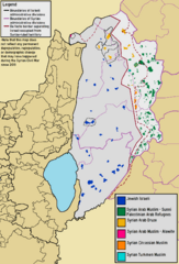
Description: Demographic map of The Golan Heights, including the Israeli-occupied "Golan Subdistrict" and the Syrian-ruled "Quneitra Governorate".
Title: Demographic map of the Golan Heights - Legend
Credit: Own work
Author: BasilLeaf, using original work created by Bolter21
Usage Terms: Creative Commons Attribution-Share Alike 4.0
License: CC BY-SA 4.0
License Link: https://creativecommons.org/licenses/by-sa/4.0
Attribution Required?: Yes
Image usage
The following 2 pages link to this image:

All content from Kiddle encyclopedia articles (including the article images and facts) can be freely used under Attribution-ShareAlike license, unless stated otherwise.