
Image: Detail from plate 105 of Taylor and Skinner's Maps Of The Roads Of Ireland

Size of this preview: 760 × 599 pixels. Other resolutions: 304 × 240 pixels | 795 × 627 pixels.
Original image (795 × 627 pixels, file size: 128 KB, MIME type: image/jpeg)
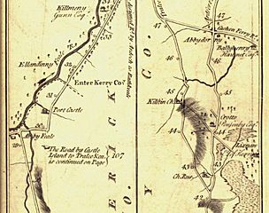
Description: A detail from Taylor and Skinner's book of 1777 showing the road from Tralee to Listowel. Kilflynn ('Kilftyn'), Abbeydorney ('Abbydorney'), Lixnaw and Crotto (seat of the Ponsonby family at the time) are clearly shown.
Title: Detail from plate 105 of Taylor and Skinner's Maps Of The Roads Of Ireland
Credit: Taylor and Skinner's Maps of the Roads of Ireland Survey 1777
Author: George Taylor, Andrew Skinner
Usage Terms: Public domain
License: Public domain
Attribution Required?: No
Image usage
The following page links to this image:

All content from Kiddle encyclopedia articles (including the article images and facts) can be freely used under Attribution-ShareAlike license, unless stated otherwise.