
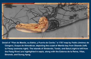
Image: Detail of Plan de Manila su Bahia y Puerto de Cavite Depicting Binondo Tondo and Isla de Balut in 1787

Size of this preview: 800 × 517 pixels. Other resolutions: 320 × 207 pixels | 2,274 × 1,469 pixels.
Original image (2,274 × 1,469 pixels, file size: 2.12 MB, MIME type: image/png)
Description: Detail of the Duque de Almadovar's 1787 "Plan de Manila su Bahia y Puerto de Cavite" with the islands of Binondo, Tondo, and Isla de Balut highlighted in Sepia.png
Title: Detail of Plan de Manila su Bahia y Puerto de Cavite Depicting Binondo Tondo and Isla de Balut in 1787
Credit: Original publication: Madrid Immediate source: Personal digital images collection.
Author: Duque de Almadovar Pedro Jiménez de Góngora (Life time: 1727-1794)
Usage Terms: Public domain in the United States
License: Public domain
Attribution Required?: No
Image usage
The following page links to this image:

All content from Kiddle encyclopedia articles (including the article images and facts) can be freely used under Attribution-ShareAlike license, unless stated otherwise.