
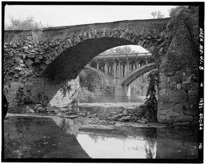
Image: Detailed, telephoto view of collapsed arch. - National Road, Wilson Bridge, Spanning Conococheague Creek at Route 40 (Old), Hagerstown, Washington County, MD HAER MD,22-HAGTO.V,2-8

Size of this JPG preview of this TIF file: 747 × 600 pixels. Other resolution: 299 × 240 pixels.
Original image (4,949 × 3,972 pixels, file size: 18.75 MB, MIME type: image/tiff)
Title: Detailed, telephoto view of collapsed arch. - National Road, Wilson Bridge, Spanning Conococheague Creek at Route 40 (Old), Hagerstown, Washington County, MD
Credit: https://www.loc.gov/pictures/item/md0834.photos.085000p
Permission: Public domainPublic domainfalsefalse This image or media file contains material based on a work of a National Park Service employee, created as part of that person's official duties. As a work of the U.S. federal government, such work is in the public domain in the United States. See the NPS website and NPS copyright policy for more information.
Usage Terms: Public domain
License: Public domain
Attribution Required?: No
Image usage
The following page links to this image:

All content from Kiddle encyclopedia articles (including the article images and facts) can be freely used under Attribution-ShareAlike license, unless stated otherwise.