
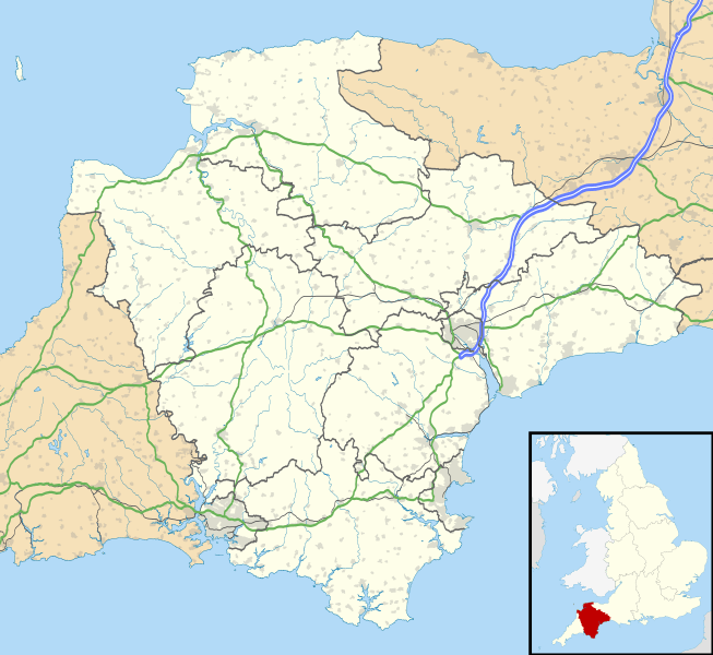
Image: Devon UK location map

Description: Map of Devon, UK with the following information shown: Administrative borders Coastline, lakes and rivers Motorways and primary routes Urban areas Equirectangular map projection on WGS 84 datum, with N/S stretched 150% Geographic limits: West: 4.72W East: 2.86W North: 51.3N South: 50.16N
Title: Devon UK location map
Credit: Ordnance Survey OpenData. Administrative borders and coastline data from Boundary-Line product. All other geographic data from Meridian 2 product. Inset derived from England location map.svg by Spischot.
Author: Nilfanion, created using Ordnance Survey data
Permission: This file is licensed under the Creative Commons Attribution-Share Alike 3.0 Unported license. Attribution: Contains Ordnance Survey data © Crown copyright and database right You are free: to share – to copy, distribute and transmit the work to remix – to adapt the work Under the following conditions: attribution – You must attribute the work in the manner specified by the author or licensor (but not in any way that suggests that they endorse you or your use of the work). share alike – If you alter, transform, or build upon this work, you may distribute the resulting work only under the same or similar license to this one. http://creativecommons.org/licenses/by-sa/3.0 CC BY-SA 3.0 Creative Commons Attribution-Share Alike 3.0 truetrue
Usage Terms: Creative Commons Attribution-Share Alike 3.0
License: CC BY-SA 3.0
License Link: http://creativecommons.org/licenses/by-sa/3.0
Attribution Required?: Yes
Image usage
More than 100 pages link to this image. The following list shows the first 100 page links to this image only. A full list is available.
- Affeton Castle
- Alverdiscott
- Ashburton, Devon
- Axminster
- Axminster Museum
- Bampton, Devon
- Bampton Castle, Devon
- Barnstaple
- Bayard's Cove Fort
- Beer, Devon
- Berry Head Lighthouse
- Bideford
- Bigbury-on-Sea
- Birch Tor and Vitifer mine
- Bovey Tracey
- Bowden Fort
- Bradninch
- Brisworthy stone circle
- Brixham
- Broadsands Chambered Tomb
- Brownhill Battery
- Buckfastleigh
- Bucks Mills
- Budleigh Salterton
- Chagford
- Chudleigh
- Chulmleigh
- Churston Woods
- Clayhanger, Devon
- Clovelly
- Colebrooke, Devon
- Colyton, Devon
- Compton, Plymouth
- Cranmore Castle
- Crediton
- Croyde
- Cullompton
- Dartmouth, Devon
- Dartmouth Castle
- Dawlish
- Dawlish Warren
- Devonport, Plymouth
- Drake's Island
- Drizzlecombe
- Dunkeswell
- Eddystone Rocks
- Egg Buckland Keep
- Eggbuckland
- Exmouth
- Exton, Devon
- Eylesbarrow mine
- Fordy Wood Copse
- Fort Austin
- Fort Efford
- Fosse Copse
- Frobisher Battery
- Furzehill Plantation
- Goodrington
- Great Torrington
- Hartland, Devon
- Hatherleigh
- Higher Barracks, Exeter
- Honiton
- Hooe, Plymouth
- Huntsham
- Ilfracombe
- Ivybridge
- Kingsbridge
- Kingsteignton
- Lynmouth
- Lynton
- Modbury
- Moretonhampstead
- Morice Town
- Newton Abbot
- North Tawton
- Northam, Devon
- Okehampton
- Ottery St Mary
- Paignton
- Plympton
- Princetown
- Rockbeare
- Royal Citadel, Plymouth
- Salcombe
- Seaton, Devon
- Sidmouth
- South Brent
- South Molton
- St Budeaux
- St Nicholas' Priory, Exeter
- St Thomas, Exeter
- Stoke, Plymouth
- Strete
- Tavistock
- Teignmouth
- Tipton St John
- Tiverton, Devon
- Topsham, Devon
- Torquay
