
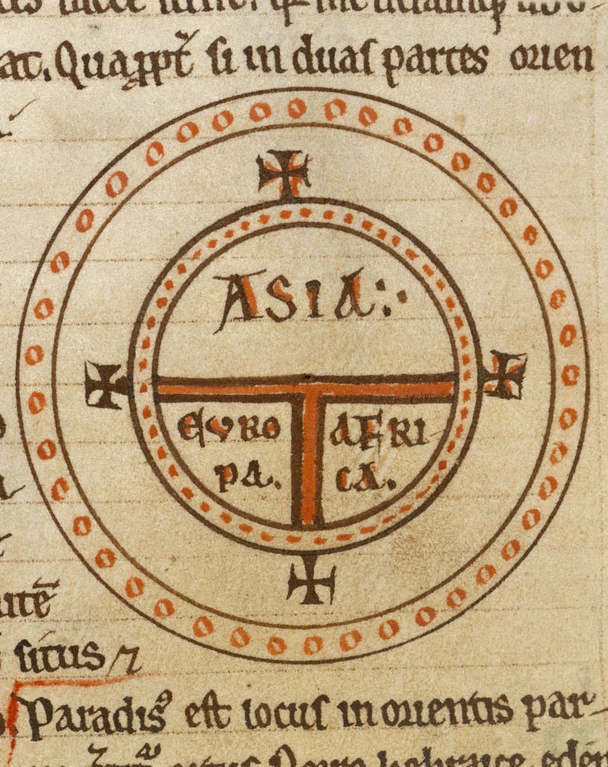
Image: Diagrammatic T-O world map - 12th century
Description: T and O style mappa mundi (map of the known world) from the first printed version of Isidorus' Etymologiae (Kraus 13). The book was written in 623 and first printed in 1472 at Augsburg by one Günther Zainer (Guntherus Ziner), Isidor's sketch thus becoming the oldest printed map of the occident. Note: T-O-maps are typically displayed "East-up", show Jerusalem at the center and the paradise at the outmost East, balanced by the pillars of Hercules at the outmost West. Title of Book: Etymologies Author: Isidore, Saint, Bishop of Seville Production: 12th century Language: Latin From The British Library; Record Number - c5933-06; Shelfmark - Royal 12 F. IV; Page Folio Number - f.135v.
Title: Diagrammatic T-O world map - 12th century
Credit: Losslessly cropped from http://www.imagesonline.bl.uk/britishlibrary-store/Components/707/70737_2.jpg at [1]
Author: Isidore of Seville
Usage Terms: Public domain
License: Public domain
Attribution Required?: No
Image usage
The following 2 pages link to this image:
