
Image: Dirtlow Rake - geograph.org.uk - 2368667
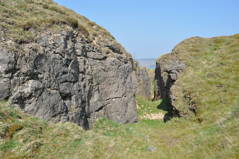
Description: Dirtlow Rake, near to Castleton, Derbyshire, Great Britain. Dirtlow Rake is a series of open and underground workings following a series of mineral veins. Rake is another meaning for vein, although the veins are long and sometimes rather thick. This rake runs along a fault line, horizontal slikensides have been observed, vertical displacement has been estimated at 20-30m. The lead and Zinc veins here (Galena/Sphalerite) have been mined for centuries, later on the gangue minerals (waste) became valuable and mined in their own right. Notably calcite, barytes and flurospar, its also worth mentioning not far away the flurospar 'blue john' is/was extracted. The veins formed when around 2km down hot fluids around 120 degrees C dissolved ions from the shales alongside<a href="https://www.geograph.org.uk/photo/2366518">SK1383 : Mam Tor</a>. These fluids moved laterally before reaching oxygenated and slightly sulphuric ground waters in the limestone, this caused the minerals to precipitate out. These waters moved along cracks and faults. The site is on private land and permission to enter must be sought. This description was sourced from 'The geological setting of the lead mines in the northern part of the White Peak, Derbyshire' by Trevor D Ford (2010). Care must be taken in this area as there are hidden shafts (open), the most dangerous ones have grills.
Title: Dirtlow Rake - geograph.org.uk - 2368667
Credit: From geograph.org.uk; transferred by User:Rubberstamp using geograph_org2commons.
Author: Ashley Dace
Permission: Creative Commons Attribution Share-alike license 2.0
Usage Terms: Creative Commons Attribution-Share Alike 2.0
License: CC BY-SA 2.0
License Link: https://creativecommons.org/licenses/by-sa/2.0
Attribution Required?: Yes
Image usage
The following page links to this image:
