
Image: Drake Park Neighborhood HD boundary map

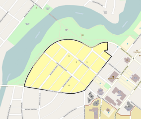
Description: Map showing the boundaries of the Drake Park Neighborhood Historic District in Bend, Oregon, United States. The historic district is listed on the US National Register of Historic Places. Boundary data is derived from the historic district's National Register nomination form. Black boundary/yellow area: Drake Park Neighborhood Historic District boundaries. Brown boundary/tan area: Boundaries of the nearby Old Town Historic District. Numbers: Represent the locations of contributing resources in the historic district that are also listed individually on the National Register: Benjamin Hamilton House Robert D. Moore House George Palmer and Dorothy Binney Putnam House Thomas McCann House
Title: Drake Park Neighborhood HD boundary map
Credit: Exported screenshot from OpenStreetMap, with district boundaries and shading and some titles drawn by uploader.
Author: Base map: OpenStreetMap contributors District boundaries/shading: Ian Poellet (User:Ipoellet)
Permission: Base map: © OpenStreetMap contributors. Current license information available at http://www.openstreetmap.org/copyright.
Usage Terms: Creative Commons Attribution-Share Alike 2.0
License: CC BY-SA 2.0
License Link: https://creativecommons.org/licenses/by-sa/2.0
Attribution Required?: Yes
Image usage
The following page links to this image:
