
Image: Dujaila Redoubt Map from The Campaign in Mesopotamia 1914-1918. Volume II

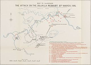
Description: Dujaila Redoubt Map from The Campaign in Mesopotamia 1914-1918. Volume II The map accompanies The Campaign in Mesopotamia 1914-1918. Volume II , and shows a region around the Dujaila watercourse [Nahr ad Dujaylah] in central and eastern Iraq, indicating military operations, towns, settlements, rivers and marshes. A key in the lower right corner explains numbered locations on the map. Prepared in the Historical Section of the Committee of Imperial Defence, and printed at the Ordnance Survey in 1924. Scale approximately 1:190,000 Scale designator Horizontal Orientation North Degree coordinates Top-left: 32° 44' 13.2" N, 45° 43' 10.56" E Top-right: 32° 44' 13.2" N, 46° 19' 30.72" E Bottom-left: 32° 22' 30" N, 45° 43' 10.56" E Bottom-right: 32° 22' 30" N, 46° 19' 30.72" E Physical characteristics Materials: Printed in colour on paper Dimensions: 230 x 325mm, on sheet 317 x 405mm Written in English in Latin script
Title: Dujaila Redoubt Map from The Campaign in Mesopotamia 1914-1918. Volume II
Credit: https://www.qdl.qa/en/archive/81055/vdc_100045738552.0x000036
Author: Søgeord: Aylmer, F.J.; Chamberlain, J. Austen; Suliman Pak; Duff, B.; von der Goltz; Gorringe; Halil Pasha; Lord Hardinge of Penshurst; Kut al Amara; Lake, P.H.N.; General J.E. Nixon; Townshend, C.V.F.; Tyrkiske Hær; Shatt el Arab; Nasiriya; Lord Crewe; Basra; Barrett, A.A.; Baku; Bicharakoff; Dunsterville, L.C.; von Falkenhayn; Marshall, W.R.; Maude, F.S.; Robertson, W.R.; Wilson, H.H.; Baratoff, N.N.; Cobbe, A.S.; Jabal Hamrin; Sannaiyat; Shatt al Adjaim;
Usage Terms: Open Government License 2
License: OGL 2
License Link: http://www.nationalarchives.gov.uk/doc/open-government-licence/version/2
Attribution Required?: Yes
Image usage
The following page links to this image:
