
Image: EO-1 ALI image of the flooding in Rockhampton (close-up)
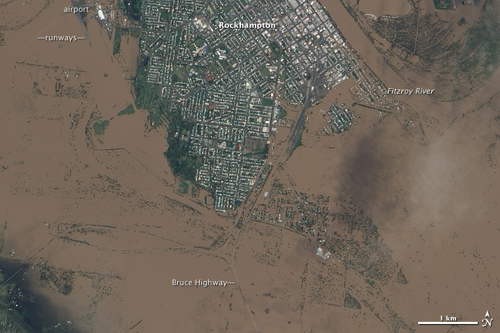
Description: NASA image acquired January 9, 2011 The airport, Bruce Highway, and large swaths of Rockhampton remained underwater on January 9, 2011. Days of rain pushed the Fitzroy River over its banks, inundating parts of the city near the Queensland coast. Damage to Bruce Highway was not confined to Rockhampton; on January 11, 2011, ABC News Australia reported that other parts of the highway, in southeastern Queensland, were expected to remain underwater for some time. In this image, acquired by the Advanced Land Imager (ALI) on NASA’s Earth Observing-1 (EO-1) satellite on January 9, 2011, isolated islands of cityscape poke through murky brown flood waters. The Fitzroy River cuts through the upper right quadrant of the image, and just west of the river, relatively high land remains above the flood. All around that area, flood water predominates, including areas east of the river. Rockhampton was just one of many Australian communities reeling from floods, according to news reports. Farmers along the Sunshine Coast were stranded by high waters that washed out roads. Authorities in Brisbane, Australia’s third-largest city, told residents to evacuate in anticipation of the worst flooding in several decades. NASA Earth Observatory image created by Jesse Allen, using EO-1 ALI data provided courtesy of the NASA EO-1 team. Caption by Michon Scott. Instrument: EO-1 - ALI Credit: <a href="http://www.earthobservatory.nasa.gov/" rel="nofollow"> NASA Earth Observatory</a> <a href="http://www.nasa.gov/centers/goddard/home/index.html" rel="nofollow">NASA Goddard Space Flight Center</a> enables NASA’s mission through four scientific endeavors: Earth Science, Heliophysics, Solar System Exploration, and Astrophysics. Goddard plays a leading role in NASA’s accomplishments by contributing compelling scientific knowledge to advance the Agency’s mission. Follow us on <a href="http://twitter.com/NASA_GoddardPix" rel="nofollow">Twitter</a> Join us on <a href="http://www.facebook.com/pages/Greenbelt-MD/NASA-Goddard/395013845897?ref=tsd" rel="nofollow">Facebook</a> To see more images from this event go to: <a href="http://earthobservatory.nasa.gov/NaturalHazards/event.php?id=48320" rel="nofollow">earthobservatory.nasa.gov/NaturalHazards/event.php?id=48320</a>
Title: EO-1 ALI image of the flooding in Rockhampton (close-up)
Credit: Flickr: Flooding in Australia [Detail]
Author: NASA Goddard Space Flight Center
Permission: This image, which was originally posted to Flickr.com, was uploaded to Commons using Flickr upload bot on 16:57, 12 January 2011 (UTC) by Bidgee (talk). On that date, it was available under the license indicated. This file is licensed under the Creative Commons Attribution 2.0 Generic license. You are free: to share – to copy, distribute and transmit the work to remix – to adapt the work Under the following conditions: attribution – You must attribute the work in the manner specified by the author or licensor (but not in any way that suggests that they endorse you or your use of the work). http://creativecommons.org/licenses/by/2.0 CC BY 2.0 Creative Commons Attribution 2.0 truetrue
Usage Terms: Creative Commons Attribution 2.0
License: CC BY 2.0
License Link: http://creativecommons.org/licenses/by/2.0
Attribution Required?: Yes
Image usage
The following page links to this image:

.jpg)