
Image: EelRiverHumboldt

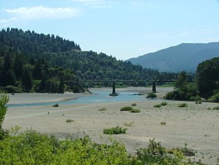
Description: Dyerville is located to the right of this photo along a sliver of land behind state park land along the North Fork of the Eel River. The South Fork merges from the right. Dyerville is bordered on the west side by Humboldt Redwoods State Park, notably Founders Grove. Avenue of the Giants, the old Highway 101, cuts through this portion of the park. The four-lane Highway 101 is also to the right of this photo. Some residents remain in the area generally regarded as Dyerville, which once was a bustling place along the railroad, evidence by the railroad trestle shown in the photo. The railroad is shut down between Willits and Samoa.
Title: EelRiverHumboldt
Credit: Own work
Author: Jan Kronsell
Usage Terms: Public domain
License: Public domain
Attribution Required?: No
Image usage
The following 3 pages link to this image:
