
Image: Epirus 1205-1230-en

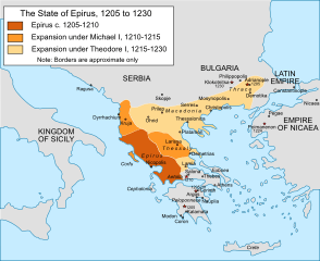
Description: Map of the territorial expansion of the principality of Epirus under its first two rulers, Michael I Komnenos Doukas (1205-15) and Theodore Komnenos Doukas (1215-30), including Theodore's "Empire of Thessalonica".
Title: Epirus 1205-1230-en
Credit: Own work, extensive correction and reworking of File:Epiro 1205-1230.svg based on: John Van Antwerp Fine, The Late Medieval Balkans: A Critical Survey from the Late Twelfth Century to the Ottoman Conquest (1994); Konstantinos Varzos, Η Γενεαλογία των Κομνηνών (1984); Donald M. Nicol, The Despotate of Epiros (1957). Note: the map concerns a subject covered with little detail by the sources, and is intended to give an approximate overview of the topic in broad outlines. It is not meant to be a detailed political map, and the boundaries shown are approximate. Any suggestion for correction or improvement is welcome.
Author: Cplakidas
Usage Terms: Creative Commons Attribution-Share Alike 4.0
License: CC BY-SA 4.0
License Link: https://creativecommons.org/licenses/by-sa/4.0
Attribution Required?: Yes
Image usage
The following page links to this image:
