
Image: Europe 1871 map en

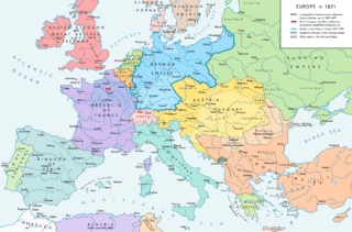
Description: Europe 1871. Historical map of the political situation after the Franco-Prussian War (1870-1871) and the formation of the German Empire. Please don't alter the map, when you think there something not written or depicted correctly. Leave a message at the talk page of the file. After a verificiation and a possible discussion, i will upload a new map version with all new changes. This prevents an unnecessary waste of disc space and ensures a good result, aesthetically and contentwise. - The author.
Title: Europe 1871 map en
Credit: Own work. Source of Information: Historical atlases and maps – Ramsay Muir, George Philip (ed.): Philip's New School Atlas of Universal History, George Philip & Son, Ltd., London 1928 – Dr. Walter Leisering (ed.): Putzger Historischer Weltatlas, Cornelsen Verlag, Berlin 1992, ISBN 3-464-00176-8 – Bayerischer Schulbuch-Verlag (ed.): Großer Historischer Weltatlas, Dritter Teil, Neuzeit, Bayerischer Schulbuch-Verlag, München 1981, ISBN 3-7627-6021-7. – Prof. Dr. Vadim Oswalt u. Prof. Dr. Hans Ulrich Rudolf (ed.): Klett-Perthes Atlas zur Weltgeschichte, Ernst Klett Verlag, Stuttgart 2011, ISBN 978-3-12-828194-0 – Ziegelbrenner: Karte des Deutschen Reichs 1871-1918, 22 June 2016 version (map link) Other publications – Raymond Poidevin u. Jacques Bariéty: Frankreich und Deutschland. Die Geschichte ihrer Beziehungen 1815-1975, Verlag C. H. Beck, München 1982, ISBN 3-406-04124-8 – Francesco Traniello u. Gianni Sofri: Der lange Weg zur Nation. Das italienische Risorgimento, Verlag W. Kohlhammer, Stuttgart 2012, ISBN 978-3-17-021898-7
Author: Alexander Altenhof
Usage Terms: Creative Commons Attribution-Share Alike 4.0
License: CC BY-SA 4.0
License Link: http://creativecommons.org/licenses/by-sa/4.0
Attribution Required?: Yes
Image usage
The following page links to this image:
