
Image: Falkland-Islands-Chart-Charles-Barnard-1815

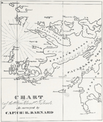
Description: Pre 1829 map of a part of the Falkland Islands, first published in Charles Barnard's 1829 book. (The title Map of a Part of the Falkland Islands: From the original survey made in 1815 by Capt. Charles H. Barnard given in the source book is erroneous, for Barnard left the islands in 1814 and was well away from the South Atlantic in 1815)
Title: Falkland-Islands-Chart-Charles-Barnard-1815
Credit: C. Barnard, J. Nicol, J. Knights, W. Mariner and J. Bartlett. The sea, the ship and the sailor. Tales of adventure from log books and original narratives. Salem, Massachusetts: Marine Research Society, 1925 (following p. 14)
Author: Charles H. Barnard (1781–1840)
Usage Terms: Public domain
License: Public domain
Attribution Required?: No
Image usage
The following 4 pages link to this image:
