
Image: FallsMap10Romani

Size of this preview: 800 × 529 pixels. Other resolutions: 320 × 211 pixels | 3,146 × 2,079 pixels.
Original image (3,146 × 2,079 pixels, file size: 1.05 MB, MIME type: image/jpeg)
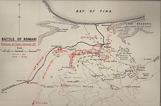
Description: Battle of Romani map shows positions at 16:00 on 4 August 1916
Title: FallsMap10Romani
Credit: Official History of the Great War Military Operations Egypt and Palestine Volume 1 From the outbreak of war with Germany to June 1917
Author: Cyril Falls and George MacMunn (maps)
Usage Terms: Public domain
License: PD
Attribution Required?: No
Image usage
The following page links to this image:

All content from Kiddle encyclopedia articles (including the article images and facts) can be freely used under Attribution-ShareAlike license, unless stated otherwise.