
Image: Fema827map
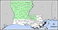
Description: Summary Map of counties eligible for debris removal and emergency protective measures, including direct Federal assistance, will be provided at 75 percent Federal funding. Other counties were eligible for similar measures, without the 75 percent limit.[1][2] en:Category:Hurricane Katrina
Title: Fema827map
Credit: http://www.fema.gov/news/event.fema?id=4786
Author: User Hipocrite on en.wikipedia
Permission: This image is a work of a Federal Emergency Management Agency employee, taken or made as part of that person's official duties. As works of the U.S. federal government, all FEMA images are in the public domain in the United States. Additional media usage information may be found at https://www.fema.gov/photo-video-audio-use-guidelines
Usage Terms: Public domain
License: Public domain
Attribution Required?: No
Image usage
The following page links to this image:
