
Image: Fes walls history 4 - early 17th century (Saadian period)

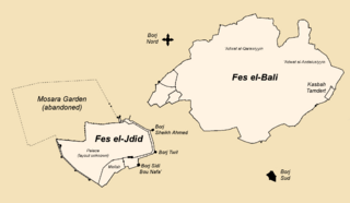
Description: Map 4 of 5, showing Fes at the end of the Saadian period in the early 17th century. Map based on original map "Carte Fortifications de Fes - Saadiens.PNG" by Omar-toons, but with major changes and new work added. Changes include updates to spelling to be consistent with maps and names in main source (below). Some names and labels have been added and others removed, in order to focus on the Saadian-period changes. To reduce clutter and distractions, I've decided to forego the grey outlines of future walls which were present in the original file. Significant changes have been made to the western part of the map around Kasbah Bou Jeloud, as I redrew this part by following the outline of the western Fes el-Bali walls that are shown in the maps from the sources below. Significant changes have been made to the Fes Jdid walls, including, but not limited to: redrawing the walls of the Mellah to reflect the sources, illustrating the Marinid double walls and their gates and fortifications, removing the Dar al-Makhzen walls (because those were the present-day walls and the form of the original palaces is not known), and adding the walled Mosara Garden to the north. (Note: Bressolette and Delaroziere's 1978 article theorizes that the Mosara Garden began to disappear in the Saadian period, once the Marinids were no longer there to maintain it, and so that's why I've presented them as "abandoned" here; they eventually disappeared almost completely, though some archeological remains are visible in the Bab Segma Cemetery which occupies a lot of this area today.) Sources: Le Tourneau, Roger (1949). "Fès avant le protectorat: étude économique et sociale d'une ville de l'occident musulman". A copy of the same maps, as well as other useful maps where the outlines of the western well are a little more distinct, can be accessed in this UNESCO report (see page 4 and after): https://unesdoc.unesco.org/ark:/48223/pf0000039605?posInSet=17&queryId=N-EXPLORE-cad3fb24-479f-4d70-bac6-6a01dc836092 ) Bressolette, Henri; Delaroziere, Jean (1983). "Fès-Jdid de sa fondation en 1276 au milieu du XXe siècle". Hespéris-Tamuda. XX–XXI: 245–318. Bressolette, Henri; Delarozière, Jean (1978). "El Mosara, jardin royal des Mérinides". Hespéris-Tamuda: 51–61.
Title: Fes walls history 4 - early 17th century (Saadian period)
Credit: Wiki Commons
Author: Base map: Omar-toons Major modifications: R Prazeres
Usage Terms: Creative Commons Attribution-Share Alike 4.0
License: CC BY-SA 4.0
License Link: https://creativecommons.org/licenses/by-sa/4.0
Attribution Required?: Yes
Image usage
The following page links to this image:

.png)