
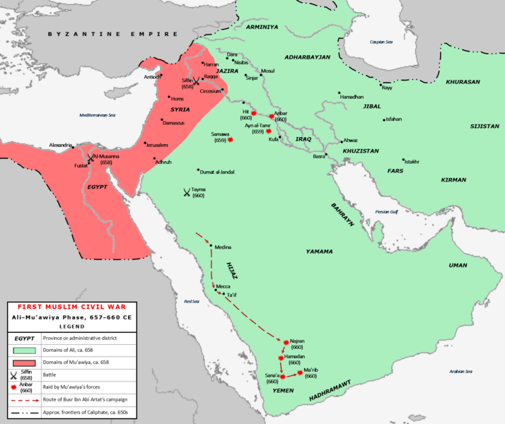
Image: First Fitna Map, Ali-Muawiya Phase

Description: Map of the conflict between Caliph Ali (r. 656-661) and Governor of Syria Mu'awiya ibn Abi Sufyan during the First Muslim Civil War. The area shaded in green represents the territories of the Caliphate under Ali's control following the capture of Egypt by Mu'awiya's ally and deputy Amr ibn al-As in 658; the area in shaded in pink represents Mu'awiya's domains. Battles, raids by Mu'awiya's lieutenants and the military expedition route of Mu'awiya's lieutenant Busr ibn Abi Artat are all indicated. The frontiers of the Caliphate are approximate. Sources: Madelung, Wilferd (1997). The Succession to Muhammad: A Study of the Early Caliphate. Cambridge: Cambridge University Press. ISBN 0-521-56181-7, pages 184–310.
Title: First Fitna Map, Ali-Muawiya Phase
Credit: Own work
Author: Al Ameer son
Usage Terms: Creative Commons Attribution-Share Alike 4.0
License: CC BY-SA 4.0
License Link: https://creativecommons.org/licenses/by-sa/4.0
Attribution Required?: Yes
Image usage
The following 2 pages link to this image:
