
Image: Forks of White Clay

Size of this preview: 800 × 600 pixels. Other resolutions: 320 × 240 pixels | 2,816 × 2,112 pixels.
Original image (2,816 × 2,112 pixels, file size: 2.75 MB, MIME type: image/jpeg)
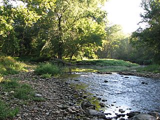
Description: Forks of the White Clay Creek, Pennsylvania, as seen from the former site of the Yeatmans Station Road bridge. The East Branch is on the right, and the combined Middle and West Branches on the left. This was the site of the Indian town of Opasiskunk, and lies in what is now the White Clay Creek Preserve.
Title: Forks of White Clay
Credit: Own work
Author: Choess
Usage Terms: Creative Commons Attribution-Share Alike 3.0
License: CC BY-SA 3.0
License Link: https://creativecommons.org/licenses/by-sa/3.0
Attribution Required?: Yes
Image usage
The following 2 pages link to this image:

All content from Kiddle encyclopedia articles (including the article images and facts) can be freely used under Attribution-ShareAlike license, unless stated otherwise.