
Image: Frankfurt airport hub map v2

Size of this preview: 764 × 600 pixels. Other resolutions: 306 × 240 pixels | 1,158 × 909 pixels.
Original image (1,158 × 909 pixels, file size: 1.03 MB, MIME type: image/png)
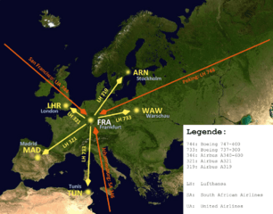
Description: A map of Europe to show how an airport-hub is working. Using the example of Lufthansa based in FRA/EDDF. I added some common routes and common aircraft types, flying this route. For better understanding I added a caption.
Title: Frankfurt airport hub map v2
Credit: Frankfurt_airport_hub_map.png
Author: derivative work: Upon a tree (talk) Frankfurt_airport_hub_map.png: Upon a tree
Usage Terms: Creative Commons Attribution-Share Alike 3.0
License: CC BY-SA 3.0
License Link: http://creativecommons.org/licenses/by-sa/3.0
Attribution Required?: Yes
Image usage
The following page links to this image:

All content from Kiddle encyclopedia articles (including the article images and facts) can be freely used under Attribution-ShareAlike license, unless stated otherwise.