
Image: Frontier of NY in Revolution German Flatts Attack

Size of this preview: 800 × 569 pixels. Other resolutions: 320 × 228 pixels | 3,245 × 2,310 pixels.
Original image (3,245 × 2,310 pixels, file size: 1.21 MB, MIME type: image/jpeg)
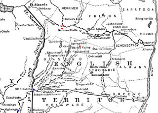
Description: Map detail of New York's western frontier in 1778. Annotated on the map are markings showing points of interest related to the Attack on German Flatts. The approximate locations of the Forts Dayton and Herkimer on either side of the Mohawk River are marked in red, as is the community of Cherry Valley. The Indian towns of Unadilla and Onaquaga (the latter spelled "Oghwaga" on the map) are marked in blue.
Title: Frontier of NY in Revolution German Flatts Attack
Credit: Derived from File:Frontier of NY in Revolution.png
Author: Image author not specified; book author Francis Whiting Halsey (1815-1919)
Usage Terms: Public domain
License: Public domain
Attribution Required?: No
Image usage
The following page links to this image:

All content from Kiddle encyclopedia articles (including the article images and facts) can be freely used under Attribution-ShareAlike license, unless stated otherwise.