
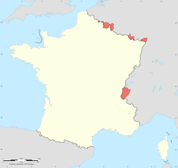
Image: Gains territoriaux de la France en 1814

Size of this PNG preview of this SVG file: 632 × 600 pixels. Other resolution: 253 × 240 pixels.
Original image (SVG file, nominally 2,000 × 1,898 pixels, file size: 314 KB)
Description: Blank map of France in 1814, with territories obtained with the 1814 Treaty of Paris (in red), but lost with the 1815 Treaty of Paris.
Title: Gains territoriaux de la France en 1814
Credit: This file was derived from: France map Lambert-93 with regions and departments-blank.svg: this map of Cambridge University Press
Author: France_map_Lambert-93_with_regions_and_departments-blank.svg: Eric Gaba (Sting - fr:Sting) derivative work: Sémhur
Usage Terms: Creative Commons Attribution-Share Alike 4.0
License: CC BY-SA 4.0
License Link: https://creativecommons.org/licenses/by-sa/4.0
Attribution Required?: Yes
Image usage
The following page links to this image:

All content from Kiddle encyclopedia articles (including the article images and facts) can be freely used under Attribution-ShareAlike license, unless stated otherwise.