
Image: Galapagos Islands topographic map-en

Size of this PNG preview of this SVG file: 600 × 600 pixels. Other resolution: 240 × 240 pixels.
Original image (SVG file, nominally 2,160 × 2,160 pixels, file size: 2.62 MB)
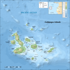
Description: Topographic and bathymetric map of the Galápagos Islands, Ecuador.
Title: Galapagos Islands topographic map-en
Credit: Galapagos_Islands_topographic_map-de.svg
Author: Galapagos_Islands_topographic_map-de.svg: Eric Gaba (Sting - fr:Sting), translated by NordNordWest derivative work: MatthewStevens (talk)
Usage Terms: Creative Commons Attribution-Share Alike 3.0
License: CC BY-SA 3.0
License Link: https://creativecommons.org/licenses/by-sa/3.0
Attribution Required?: Yes
Image usage
The following 2 pages link to this image:

All content from Kiddle encyclopedia articles (including the article images and facts) can be freely used under Attribution-ShareAlike license, unless stated otherwise.