
Image: GreaterTorontoArea2022OSM

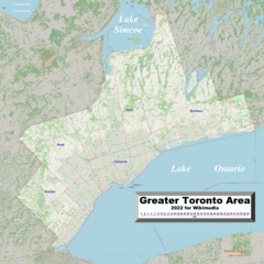
Description: This map of the Greater Toronto Area (GTA) shows the Area's cities, towns, villages and some other geographical details, and is likely the most comprehensive map of the GTA in this respect that you'll find anywhere online. It has been stitched together from panels of Open Street Map (which is freely licensed to all) with details plotted by the uploader. Further, the GTA's limits have been marked in red, and the boundaries between the constituent regions have been marked in blue, areas lying outside the GTA have been darkened, but are still readable, and locations marked in the source as airfields have been deleted wherever satellite views made it clear to the uploader that they are no longer functional.
Title: GreaterTorontoArea2022OSM
Credit: Own work
Author: Kelisi
Permission: The aforesaid website is freely usable to all.
Usage Terms: Creative Commons Attribution-Share Alike 4.0
License: CC BY-SA 4.0
License Link: https://creativecommons.org/licenses/by-sa/4.0
Attribution Required?: Yes
Image usage
The following page links to this image:
