
Image: Hatay - ethnolinguistic map

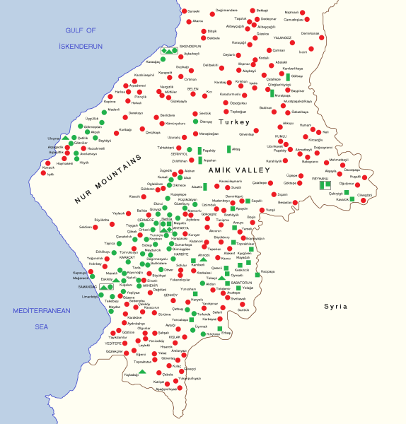
Description: Late 20th-early 21st century language distribution. Turkish (red). Arabic speakers (green) are shown by religious affiliation: Alawite (circle), Christian (triangle), Sunni (square), Bedouin Sunni (rectangle), Jewish (rhombus). In this work, Arnold Werner states scope and methodology of his research and areas covered: Werner, Arnold (1996). "Arabian dialects in the Turkish province of Hatay". Proceedings of the 2nd International Conference of l'Association Internationale pour la Dialectologie Arabe held at Trinity Hall in the University of Cambridge, 10-14 September 1995: 1-10. Map data is based on the research of Arnold Werner: In this work, Werner gives a detailed description of all Arabic speaking villages covered in his research: Werner, Arnold (1998) Die arabischen Dialekte Antiochiens, Otto Harrassowitz Verlag, pp. 329−354. ISBN: 9783447040471. In this work, Werner composed a map showing all Arabic speaking villages in Hatay covered in his research and also of surrounding Turkish villages, of which my map is based upon: Werner, Arnold (2000) "The Arabic dialects in the Turkish province of Hatay and the Aramaic dialects in the Syrian mountains of Qalamun: Two minority languages compared" in Owens, Jonathan , ed. Arabic as a minority language, Walter de Gruyter, p. 368. ISBN: 9783110805451. In this work, Werner composed a smaller map of the area focusing on the Antakya area in Hatay showing Arabic speaking villages covered in his research: Werner, Arnold (2004). "Homonymenfurcht in den arabischen Dialekten Antiochiens". Jerusalem studies in Arabic and Islam 29: 139. NOTE: My map does not show all existing Hatay settlements and their linguistic composition. Arnold Werner states that his research only covered half of the Arabic speaking villages (some 50 out of a 100). Turkish speaking villages shown on map are those covered by Werner's research. My map is based on Werner's map and data. All locations on my map replicate the geographical placement of locations, as done by Werner. At the time of Werner's publication of his works (early 2000s), a few villages had different names from what they are now and he shows them with those place names. On my map the current names are given of those few places. These settlements are: Soğukoluk > Güzelyayla; Yiğityolu > Karbeyaz; Asi > Aknehir; Güneydam > Turfanda (in this case, old name was restored).
Title: Hatay - ethnolinguistic map
Credit: Own work
Author: Resnjari
Usage Terms: Creative Commons Attribution-Share Alike 4.0
License: CC BY-SA 4.0
License Link: https://creativecommons.org/licenses/by-sa/4.0
Attribution Required?: Yes
Image usage
The following page links to this image:
