
Image: HenryHudsonTrailMarlboroRails

Size of this preview: 800 × 533 pixels. Other resolutions: 320 × 213 pixels | 2,304 × 1,536 pixels.
Original image (2,304 × 1,536 pixels, file size: 1.4 MB, MIME type: image/jpeg)
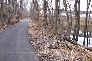
Description: Henry Hudson Trail, southernmost segment in Marlboro, just south of Vanderburg Road.
Title: HenryHudsonTrailMarlboroRails
Credit: Own work by the original uploader
Author: Wasted Time R
Usage Terms: Public domain
License: Public domain
Attribution Required?: No
Image usage
The following 10 pages link to this image:
- Beacon Hill, New Jersey
- Claytons Corner, New Jersey
- Henningers Mills, New Jersey
- Henry Hudson Trail
- Herberts Corner, Monmouth County, New Jersey
- Marlboro Township, New Jersey
- Monmouth Heights at Marlboro, New Jersey
- Mount Pleasant, Monmouth County, New Jersey
- Smocks Corner, New Jersey
- Spring Valley, New Jersey

All content from Kiddle encyclopedia articles (including the article images and facts) can be freely used under Attribution-ShareAlike license, unless stated otherwise.