
Image: Hirta map
No higher resolution available.
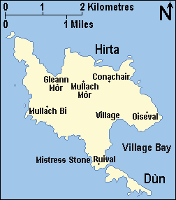
Hirta_map.PNG (252 × 286 pixels, file size: 7 KB, MIME type: image/png)
Description: Map of the island of Hirta, St Kilda, Scotland (archipelago)
Title: Hirta map
Credit: Hand drawn by User:Ruhrfisch based on maps from [1], [2], and [3], this NASA photo, and the National Geographic World Atlas.
Author: Ruhrfisch
Permission: GFDL
Usage Terms: Creative Commons Attribution-Share Alike 3.0
License: CC-BY-SA-3.0
License Link: http://creativecommons.org/licenses/by-sa/3.0/
Attribution Required?: Yes
Image usage
The following 3 pages link to this image:

All content from Kiddle encyclopedia articles (including the article images and facts) can be freely used under Attribution-ShareAlike license, unless stated otherwise.