
Image: Historical and current boundaries of Lancashire

Size of this preview: 411 × 600 pixels. Other resolutions: 164 × 240 pixels | 847 × 1,236 pixels.
Original image (847 × 1,236 pixels, file size: 191 KB, MIME type: image/png)
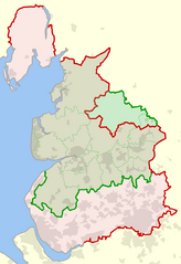
Description: The historical boundary of the county of Lancashire, England, shown in red, and the modern-day boundary (since 1974), shown in green. Also shown in dotted green are the modern-day local government districts and unitary authorities of ceremonial Lancashire.
Title: Historical and current boundaries of Lancashire
Credit: Own work
Author: Dr Greg
Usage Terms: Public domain
License: Public domain
Attribution Required?: No
Image usage
The following page links to this image:

All content from Kiddle encyclopedia articles (including the article images and facts) can be freely used under Attribution-ShareAlike license, unless stated otherwise.