
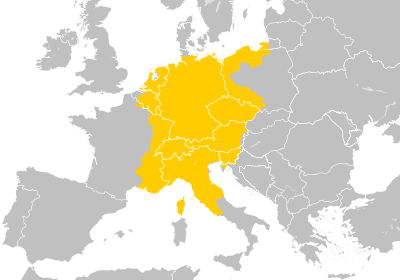
Image: Holy Roman Empire at its territorial apex (per consensus)

Description: The Holy Roman Empire at its greatest territorial extent from the early to middle 13th century (c. 1200- c. 1250). The Kingdom of Sicily, the Republic of Venice, the Kingdom of Jerusalem and other crusader states are all excluded or not depicted. Holy Roman Empire
Title: Holy Roman Empire at its territorial apex (per consensus)
Credit: Own work This file was derived from: Blank map of Europe (with disputed regions).svg: (Original version used Blank map of Europe (without disputed regions).svg) Extent of the Holy Roman Empire from Droysens-26.jpg
Author: Ernio48 (original version), Alphathon (second version)
Usage Terms: Creative Commons Attribution-Share Alike 4.0
License: CC BY-SA 4.0
License Link: https://creativecommons.org/licenses/by-sa/4.0
Attribution Required?: Yes
Image usage
The following page links to this image:

.svg)