
Image: Houston Downtown Map

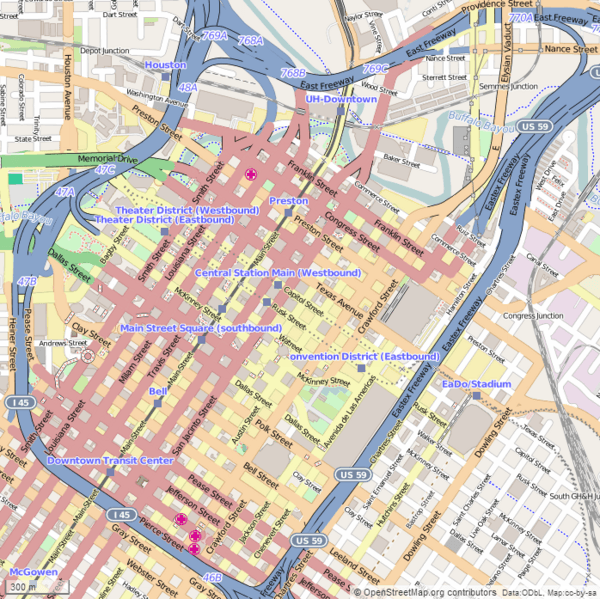
Description: This map of Downtown Houston was created from OpenStreetMap project data, collected by the community. The image should remain clear of any additional edits. To annotate the map for an article, use the Infobox or Location Map template and reference the map using map module Houston Downtown. This map may be incomplete, and may contain errors. Submit corrections to the below source link. Do not rely solely on the map for navigation. Steven Driskell Image for Map Module : Houston Downtown Latitude north = 29.76989 Latitude south = 29.74553 Longitude west = -95.37575 Longitude east = -95.34575 Map symbology
Title: Houston Downtown Map
Credit: http://www.openstreetmap.org
Author: OpenStreetMap contributors
Usage Terms: Creative Commons Attribution-Share Alike 2.5
License: CC BY-SA 2.5
License Link: https://creativecommons.org/licenses/by-sa/2.5
Attribution Required?: Yes
Image usage
The following 18 pages link to this image:
- Annunciation Church (Houston)
- Antioch Missionary Baptist Church
- Arthur B. Cohn House
- Christ Church Cathedral (Houston)
- City National Bank Building (Houston)
- Downtown Houston
- Houston Theater District
- Humble Oil Building
- Kennedy Bakery
- McKee Street Bridge
- San Jacinto Street Bridge over Buffalo Bayou
- State National Bank Building (Houston, Texas)
- Stowers Building
- Sweeney, Coombs, and Fredericks Building
- The Rice (Houston)
- The Sam Houston Hotel
- Union Station (Houston)
- United States Customhouse (Houston)
